Since 1997, Surveybase has been a trusted leader in delivering Rectified Imagery. Providing nationwide coverage, we offer precise, high-resolution imagery that is accurately scaled and geo-referenced to support your project needs.
What projects can benefit from Photogrammetry?
Rectified Imagery is highly beneficial for a wide range of projects, including:
Heritage Conservation: Essential for preserving historical sites and buildings, rectified imagery offers accurate visual documentation for restoration, maintenance, and heritage planning.
Architectural Design & Planning: Provides precise, distortion-free images for architects and designers, aiding in site analysis, building assessments, and design development.
Urban Planning & Mapping: Useful for creating detailed, accurate maps of urban areas, landscapes, and infrastructure for planning and zoning purposes.
Construction & Infrastructure Projects: Supports construction planning by providing accurate visual data for site analysis, structure alignment, and construction progress monitoring.
Land Assessment & Surveying: Helps surveyors and land assessors by offering highly detailed, scaled imagery for land surveys, boundary delineations, and environmental assessments.
Real Estate Development: Assists developers with accurate property assessments, land evaluations, and visual analysis of site conditions, enabling informed decision-making for investments.
Environmental Studies & Assessments: Ideal for creating high-accuracy visual data for environmental monitoring, ecological assessments, and landscape studies.
Legal & Compliance Projects: Provides precise imagery for legal cases or regulatory compliance, offering clear visual evidence of conditions at a specific point in time.
Rectified imagery is a versatile tool that enhances accuracy and provides clear, reliable data for a broad spectrum of industries, from heritage to modern development.
What is Rectified Imagery?
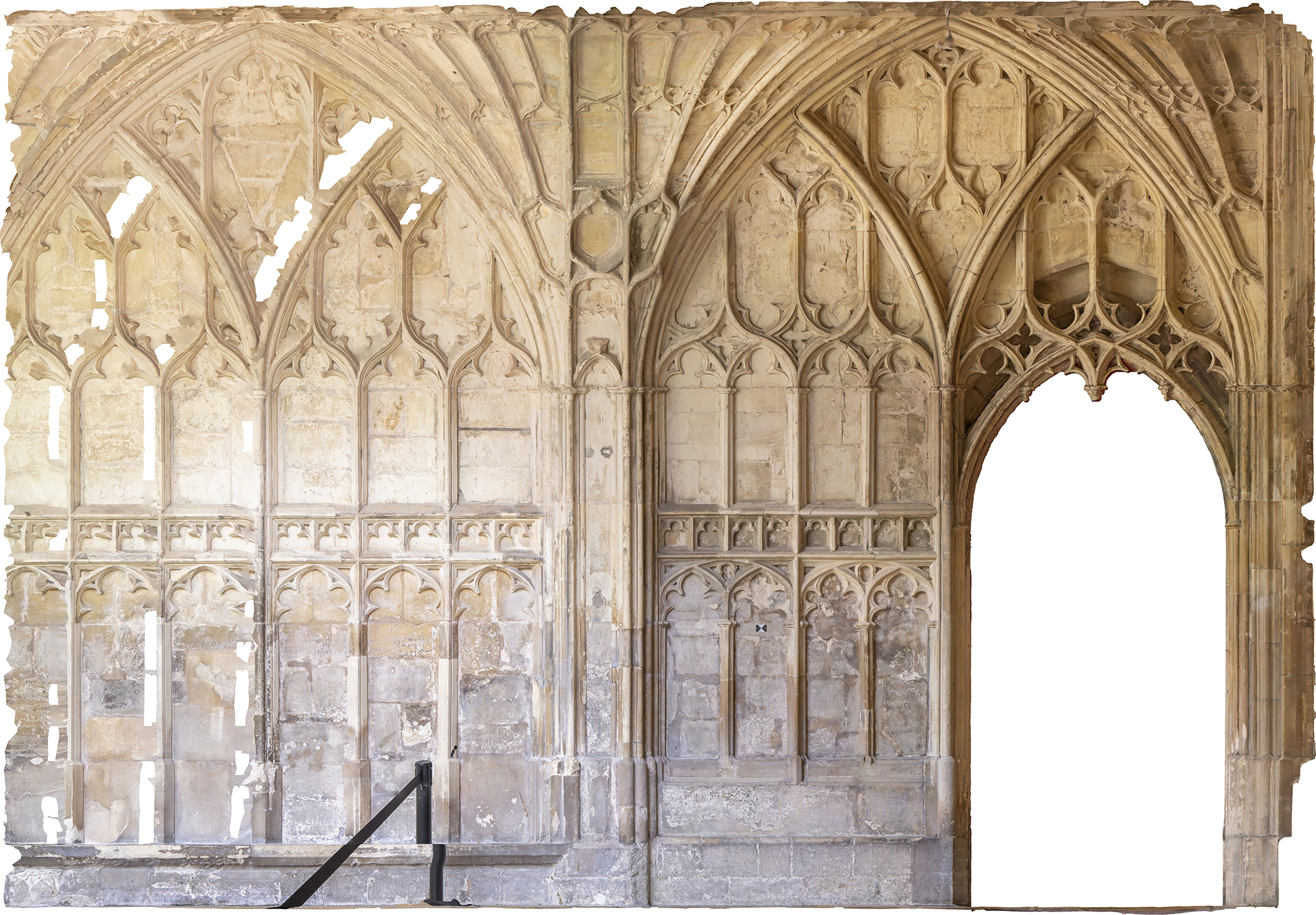
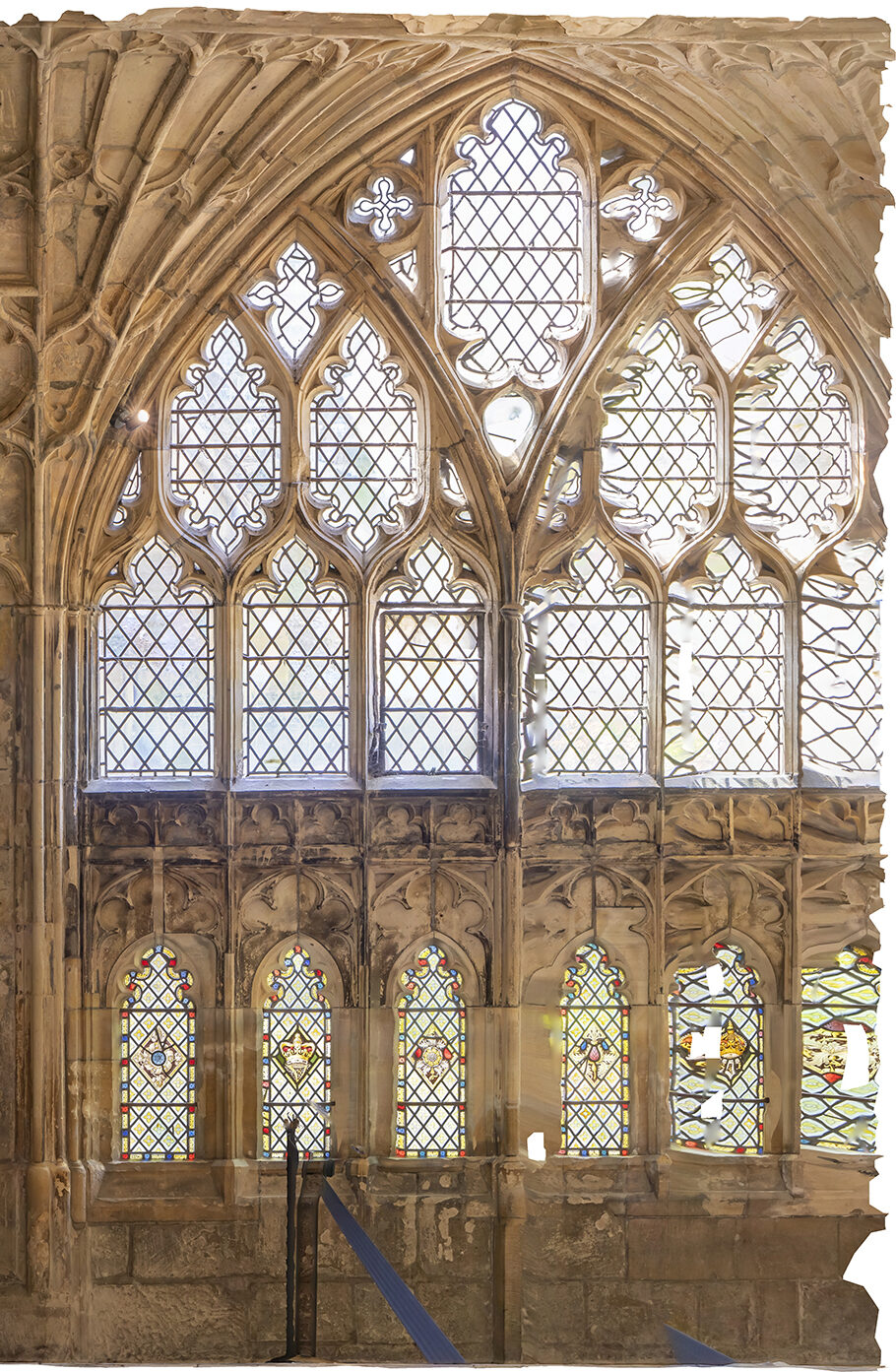
Rectified Imagery is a process in which photographs are corrected to remove distortions, ensuring they are accurately scaled and aligned with precise geographic coordinates. This technique enables the creation of detailed, reliable 2D representations of buildings, land, and other structures from photographic images. It ensures visual and measurement accuracy, making it invaluable for applications such as architectural design, mapping, land assessments, heritage conservation, and planning.
In heritage conservation, rectified imagery is used to document and preserve historical buildings and sites, providing accurate visual records that support restoration efforts and ongoing maintenance.
Typical deliverables include high-resolution rectified images, orthophotos, and scaled 2D drawings, offering clients precise visual data for informed decision-making, design, project planning, and conservation work.
Rectified Imagery
Deliverables
Rectified Photographs - JPEG & TIFF
Orthophotos - JPEG
Scaled Drawings – DWG, DXF, PDF
Sketchfab Models
3D Models – OBJ
Frequently asked questions
How is rectified imagery created?
The process involves using control points (known reference points) and specialised software to adjust the image’s geometry, correcting distortions so that the image aligns with real-world coordinates.
Do I need rectified imagery?
If you need accurate, high-quality, and measurable images for planning, surveying, or construction, rectified imagery is essential. It removes distortions, preserves image clarity, and allows you to take precise measurements without being on site.
How much does rectified imagery cost?
The cost of a Rectified Imagery can vary depending on factors such as the size and complexity of the building, location, and the level of detail required. For an accurate, no-obligation quote, feel free to get in touch with us.
Unlock the benefits of integrated surveying services with Surveybase. Our comprehensive solutions combine a range of services to deliver efficient, accurate, and cost-effective results, supporting every phase of your project with precision and reliability.
Topographical Survey
Since 1997, Surveybase has been a trusted leader in Topographical Surveys, offering nationwide coverage and delivering accurate, high-quality 2D and 3D survey data. Our proven expertise guarantees precise terrain mapping for design, planning, and compliance, ensuring total confidence in your project from the outset.
Since 1997, Surveybase has been a trusted leader in Heritage Surveying. Providing nationwide coverage, we deliver precise and dependable 2D and 3D outputs, high-resolution photography, and conservation recording, ensuring complete confidence in your project from day one.
Surveybase provides high-precision Drone Surveying & Inspection services across the UK, delivering fast, cost-effective, and detailed aerial data. Our CAA-certified pilots use advanced UAVs with high-resolution cameras and LiDAR for precise, reliable surveys.
Since 1997, Surveybase has been a trusted leader in Measured Building Surveys. Providing nationwide coverage, we deliver precise and dependable 2D and 3D outputs, ensuring complete confidence in your project from day one.
Each project highlights our dedication to accuracy, innovation, and delivering integrated surveying services. Discover how we’ve helped clients achieve successful outcomes with precise, high-quality data.
We’re here to support your project with accurate surveys and expert advice. Get in touch today to speak to one of our experts and find out how we can help.
Request a quote
To obtain a quotation, please email your survey brief to: quote@surveybase.co.ukor use our online quote portal.